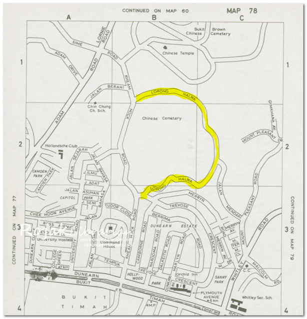
If you turn into Bukit Brown Cemetery via Kheam Hock Road, you will see a road sign called Lorong Halwa, but that is not the original Lorong Halwa. That road was created after Lornie Highway came about. The original Lorong Halwa is now an unmarked tar road a few meters down which became popular among many hikers especially during COVID-19 period when travel was curtailed due to lock down. Very few remember this trail as Lorong Halwa but many remember the Avatar Tree Trail !
The original Lorong Halwa was a very long road as you can see from the Singapore Street Directory 1975 (before Pan Island Expressway - PIE).
 |
| Lorong Halwa (1975 Singapore Street Directory) |
In another more detailed survey map dated 1970, you can see again Lorong Halwa that makes a long loop off Kheam Road and then rejoins Kheam Hock Road again near Trevose Crescent.
 |
| Singapore. Instrumental Plot (source: National Archives) |
 |
| Singapore: Instrumental Plot (source: National Archives) |
 |
| Aerial photo by Royal Air Force in 1948 of the area surrounding Lorong Halwa and Kheam Hock Road (source: National Archives) |
What happened after the construction of the PIE
Referencing back to the Singapore Street Directory, in 1984 - a few years after the PIE was built, you can see Lorong Halwa still exist but cut in 2 parts. In the Street Directory of 1991, we can see that parts of Lorong Halwa became Trevose Place !
 |
| Street Directory 1984 |
 |
| Street Directory 1991 |
As Lorong Halwa is a very long road made up of many houses and residents, we know that there are several villages along that lane that made up of both Malay and Chinese residents. Among the known name for the villages there were - Kampong Kubor (literally translated as Cemetery Village) and Tan Gu Long.
The People of Lorong Halwa
In the picture below, you can see in the background the road sign - Lorong Halwa in a well documented visit in 20 March 1966 by the Minister of Law and National Development, E. W. Baker to declare the newly metalled road and street lighting along Kampong Kubor open for use !
 |
| Lorong Halwa with tar road and street lights (source: National Archives) |
 |
| Lorong Halwa (source: National Archives) |
The next picture is from NewspaperSG which shows the aftermath of a huge storm that toppled many trees. In Lorong Halwa, 2 large trees felled across the road, affecting access. The final 2 pictures are from former residents of Lorong Halwa whom i have met in the past.
 |
| Mr. Mustaffa Sulaiman failed to get across Lorong Halwa to Kheam Hock Road because of a fallen tree (1966) |
 |
| Precious photo as a child at Lorong Halwa |
 |
| Old Singapore Identity Card of a Lorong Halwa resident |
 |
| Lorong Halwa and its numbered houses |
Lorong Halwa today
Lorong Halwa today is lovely place to explore to see how nature is making its comeback after vacated by humans due to the land acquisition act that forced the lorong halwa residents to move. If you look carefully you might spot signs of the showed there were villages once.
 |
| View of Avatar Tree trail from one side of the hill |
 |
| Water pipe along Lorong Halwa |
 |
| Electricity cable poles along Lorong Halwa |
Open call for photos
If you are a former resident of Lorong Halwa, Jalan Berahi, Kheam Hock Road, Jalan Mendaki, do share your photos with me via my email. Photos of the industry along Kheam Hock Road (e.g. the tomb masons) and Lorong Halwa is also appreciated (e.g. the abandoned cars in Lao Sua).
[research and updating of this article is still on-going]
References
Kampong's Appeal for Road, Lights Fulfilled (1966, March 21). The Straits Times, page 4
Pabila angin ribut datang.. (1975, January 24). Berita Harian
Historical Map Gallery. (website). OneMap. Singapore Land Authority
Singapore. Instrumental Plot - Lornie Road. Produced by Fairey Surveys Ltd for the Government of Singapore.
Singapore. Instrumental Plot - Adam and Thomson Road. Produced by Fairey Surveys Ltd for the Government of Singapore.
Minister for Law and National Development E W Barker being welcomed upon arrival at Kampong Kubor to declare the newly metalled road and street lighting at lorong halwa (off Kheam Hock Road). National Archives of Singapore.
Kheam Hock Road from middle bottom leading to junction with Adam Road/Lornie Road/Sime Road at top left. Bukit Brown Cemetery at top right and Seh Ong Cemetery at bottom right. National Archives of Singapore.

Comments
Post a Comment
Thank you for your comment. I can also be reached at rojaklibrarian@gmail.com